Chris Nauterski is an associate professor of atmospheric sciences at Texas A&M University.
Meteorologists began warning of severe weather, including the possibility of tornadoes, days before the storm tore through the southeastern and central United States in late March. At one point, more than 28 million people were under tornado watches. But pinpointing exactly where the tornado will touch down—as the tornado hit Rolling Fork, MississippiMarch 24, and in town Arkansas, Illinois and several other states March 31 – Still heavily dependent on seeing cyclone development on radar. Chris Nowterski, an atmospheric scientist, explains why and how forecasting technology is improving.
Why are tornadoes still so difficult to predict?
Meteorologists have gotten much better at predicting conditions that make tornadoes more likely. But predicting exactly which thunderstorms will produce a tornado and when is difficult, and that’s where much serious weather research is focused today.
Often, you’ll have a line of thunderstorms in an environment that looks favorable for tornadoes, and one storm can produce a tornado but others don’t.
The differences between them may be due to small differences in meteorological variables that are not resolved by our current observation network or computer models. Even changes in land surface conditions—fields, forested areas, or urban environments—can affect whether a tornado forms. These small changes in the storm environment can have large effects on the processes within the storm that can make or break a tornado.
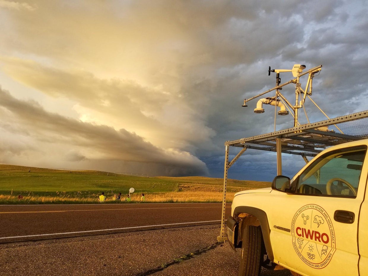
Annette Price/CIWRO
One of the strongest predictors of whether a thunderstorm develops into a tornado is related to vertical wind shear, which is how the wind changes direction or speed with height in the atmosphere.
How wind shear interacts with rain-cooled air within the storm, which we call “outflow,” and how much precipitation evaporates can affect whether a tornado forms. If you’ve ever been in a thunderstorm, you know that right before the rain starts, you often get a gust of cold air from the storm. The characteristics of the outflow of cold air are important in determining whether a tornado can form, because tornadoes usually form in the cooler part of the storm.
How far in advance can you know if a tornado will be big and strong?
Most violent tornadoes form from supercells, thunderstorms with deep rotating updrafts, called “mesocyclones”. Vertical wind shear enables the storm’s midlevel to rotate, and the upward suction from this mesocyclone can intensify the rotation in the storm’s outflow into a tornado.
If you have a supercell on the radar and it has strong rotation over the ground, it is often a precursor to a tornado. Some research suggests that a broad mesocyclone is more likely to produce a strong, long-lasting tornado than other storms.
Forecasters also look at the storm’s environmental conditions — temperature, humidity and wind shear. They also provide clues that a storm can produce a significant tornado.
Doppler radar, improved modeling, and a better understanding of storm environments have increased the percentage of tornadoes that trigger warnings in recent decades. About 87% of fatal tornadoes from 2003 to 2017 had early warnings.
Lead time for alerts has also improved. In general, now is about 10 to 15 minutes. That’s plenty of time to get to your basement or find a safe facility if you’re in or out of a trailer park. Not every storm will last that long, so it’s important to get to shelter quickly.
What are researchers discovering about tornadoes today that could help save lives in the future?
If you remember the movie “Twister” in the early 1990s, we started doing more field work on tornadoes. We were putting the radar out in the truck and driving through the storm with the roof-mounted instrument. That’s when we really start to appreciate what we call storm-scale processes – the conditions inside the storm, how temperature variations and moisture in the outflow can affect tornado potential.
Scientists can’t launch a weather balloon or send instruments into every storm, though. So, we use computers to model storms to understand what’s going on inside. Often, we will run several models, referred to as ensembles. For example, if nine out of 10 models produce a tornado, we know the storm has a good chance of producing a tornado.
The National Severe Storms Laboratory has recently been experimenting with tornado warnings based on these models, called WARN-on-Forecast, to extend tornado warning times.
There are many other areas of research. For example, to better understand how storms form, I do a lot of standard computer modeling. For this, I use a model with a simplified storm environment and make small changes to the environment to see how that changes the physics within the storm.
There’s also a new tool to chase away storms. There has been an explosion in the use of drones – scientists are placing sensors on unmanned aerial vehicles and flying them near and sometimes over cyclones.
The focus of tornado research has also shifted from the Great Plains—the traditional “tornado alley”—to the southeast.
What is different about tornadoes in the Southeast?
The southeast has somewhat different effects on storms than the Great Plains. The southeast has more trees and more varied terrain, and the atmosphere has more moisture because it is closer to the Gulf of Mexico. The Southeast also tends to have more fatalities, as more tornadoes form at night.
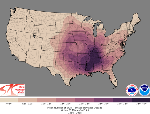
NOAA Storm Prediction Center
We see more tornadoes in the southeast that line the line of thunderstorms called “quasi-linear convective systems.” The processes that lead to tornadoes in these storms can be different, and scientists are learning more about them.
Some studies have suggested that climate change initiates tornadoes to the southeast. However, better technology to detect more tornadoes may make it harder to stem the growth of storms. Therefore, more research is needed.
This article is republished from The Conversation under a Creative Commons license.